![]()
![]()
![]()
![]()
![]()
![]()
![]()
![]()
![]()
![]()
![]()
![]()
![]()
![]()
![]()
![]()
![]()
![]()
![]()
![]()
![]()
![]()
![]()
![]()
![]()
![]()
![]()
![]()
![]()
![]()
![]()
![]()
![]()
![]()
![]()
Leg 6, Texas Soaring Association to Silvercreek Gliderport, IL - Wednesday, June 25, 2003:
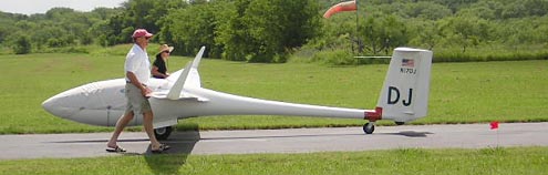
Current 15m Class
leader, Doug Jacobs, and crew getting his ASW-27 in position
at Texas Soaring Association.
Picture courtesy of David Fitch
From Tom Serkowski:
RTKH - Leg 6 report
Today's task is a short one, and then we don't have to get to Silvercreek
until tomorrow evening. It's now just a bit after 7pm, we're on the road
to spend the night at Pryor OK, which is a bit ENE of Tulsa. Tomorrow,
we'll drive 450 or so miles and try to arrive in time for a BBQ.
The forecast is for a severe front to arrive in the Dallas area sometime
this evening, so if we don't fly today, it's out of the question tomorrow.
At the 0930 meeting we're told that we will fly, but will find out the
exact goal at a 1030 meeting. Finally we get the news that we'll go about
141 miles. Not very far, but cloud bases are still quite low and it's
unclear whether they'll get much higher later. The good news is that we
have a tailwind once we get around the DFW class B airspace.
The task is Ennis and Terrell as steering points to keep us clear of the
class B, then finish at Eaker field in Durant, OK. We have the option
to finish high and continue onward if the weather permits.
The field elevation at TSA is 660 MSL and I spend the first 20 minutes
after engine shutdown between 2200 & 3300'. The clouds are impossible
to figure out as I fly fom one to the next and find nothing. I'm just
as likely to hit lift in the clear as under a cu. I launched at 1300,
but the first good climb doesn't happen until more than 25 minutes later
and I get up to the dizzying height of 4000' and near cloudbase.
After another 10 minutes of milling around at 3500' with a few other sailplanes,
I decide it's time to go. The clouds are still hard to read but they've
also changed some and look weaker. It's possible the day may just get
worse instead of better.
I came up with an interesting start strategy - get high just inside the
start cylinder right where the course exits, then fly along the inside
edge losing altitude until finally realizing that I won't get higher and
let's just go on course :) As usual, I seem to be alone at the start.
A few gliders are visible, but nobody's marking that nice juicy thermal
out on course, and others are still hanging back waiting, I suppose, for
better climbs.
The first leg is 20.7 miles and I work a couple thermals from 3K to 4K
on the way. The clouds are still impossible to figure out, and as I'm
alone, I just blunder along doing the best I can. On the next leg, things
get interesting as I drop down to 2200' before finding a reasonable thermal.
By this time, I spot a few gliders and we all make our way to the next
turn. I quickly recognize Dick Mockler in IT is leading JL and RV, so
I tag along
too. Dick's a local so he's just got to know how to get the best out of
this weather. By the time we got to Terrell, I was above everyone and
they had stopped in a junky thermal, so I just pushed on alone again.
I glide toward an airstrip as I get lower and lower. Finally, at about
2100', I find a weak thermal and grind my way back up to 3700'. On the
next glide, I spot TP thermalling ahead and for most of the rest of this
leg, we fly together. At first they're above me, but with judicious use
of leeching techniques, I eventually catch up and even get ahead for a
few minutes.
About 25 miles out, we get high enough for final glide and I ask Jim if
he plans to try to continue on past the finish. At about this time, TP
is in fornt of me and heading for a cu that's not quite on course. I turn
direct for the finish and have to cross a couple miles of blue, but beyond,
the cloud bottoms look dark and flat. I bounce these and am quickly more
than 1,000' above glide slope, so I speed up a bit and maintain this extra
altitude all the way to the goal. At the airport, I find weak lift over
the end of a runway, but it's just not going up and I only gain 300' at
about 80 fpm.
As I roll out at about 2,000' AGL, I watch TP make a low downwind leg
to a landing. I wander North a bit over town, but find nothing so eventually
end
up landing a few minutes later. I believe DJ was the first to arrive at
the goal today, but TP was the first to land. I'd sent Karen into town
to get gas in case I did get away, so she arrives at the airport about
10 minutes after I do. We hook up the towbar to 5Z and a short rope between
tow hitches to TP and drag the gliders to the ramp. As we disassemble,
most of the others arrive also.
I have no idea how the others have done, but Jim mentions a speed of a
bit over 81 mph and I'm in at just over 77. Had I pushed for a low finish,
I may have been another couple minutes faster.
It's now 10pm and I'm drying off in the hotel in Pryor. About 40 miles
out, we stopped for dinner, and when we got back in the truck, the leading
edge of the storm was visible a couple miles North of us. We drive through
some very heavy rain the rest of the way. We arrive at the hotel and see
TP crew and trailer turning around in the parking lot and Dan Gudgel,
one of our tow pilots, standing at the hotel entrance. Dan arrived earlier
at the airport behind the hotel and had checked the weather. There's a
chance of hail, so Jim's on the way to the airport to put the trailer
under a shade hangar and we follow.
So, it looks like we just squeaked in a decent flight for this quite interesting
day.
Tom Serkowski
![]()
From Dave Nadler:
The weather this morning was very discouraging. Low overcast, and humidity
so high my glasses fogged up when we walked out of the hotel. I was in
a serious funk. We went to the pilots meeting, where we were told "come
back in an hour". I went and made a database for the ILEC SN10 pilots
that covered the area where we would be tasked and helped folks get ready,
but it looked so nasty I didn't rig.
TSA (Texas Soaring Association) has a gorgeous field in Midlothian Texas.
glider hangars, a trailer hanger, nice clubhouse, towplane hangar, workshop,
all the comforts ! My TSA buddies encouraged me to stop grumbling and
start rigging, and when I heard IT climbing at a few knots I finally opened
the trailer. Fortunately the Ventus is quick and easy to rig; actually
preflight checks take longer than assembly. Finished getting ready and
blasted off just a few minutes after the last scheduled launch. I'm here
to fly !
Easy climb out, and the start gate is already open. We've got a couple
of steering turnpoints at Ennis and Terrell to keep us away from the Dallas
/ Ft Worth class B airspace, but this area is low and wet. Cloud base
is low and its actually not so strong. Better stay connected with the
clouds and tippy-toe, and hope it gets stronger and higher later. I've
got a loose gear door that's making a terrific racket, but what's really
distracting is the gliders on the ground at the first turnpoint. Careful
!
I round the second turn and keep near cloudbase. The cloudbase seems to
be around 3500 AGL. I can't go to cloudbase because of the FARs but also
because you can't see the clouds ahead if you get too high, which makes
it impossible to pick an efficient route in lift. Circle in weak stuff,
drift downwind, then bounce and weave slowly but without circling. Speed
is finally picking up with help from the 17 knot tailwind. The clouds
are working, bases are moving up, more like its supposed to be !
I finish the short 140 mile task after 2:08, but its too good to land.
After quite a struggle I climb back up (no, I didn't use the motor) and
keep heading north. DJ is as usual out in front, and I think Natalie (22)
and Alfred (AS) are out here too. Crew David Fitch is keeping up with
me (I'm being slow), and we keep in touch as he motors up Route 69/75.
Keep bumping the clouds, drifting downwind onwards into Oklahoma. Atoka,
McAlister, and now I've gone and flown off the end of my GPS database.
Oh well, navigate the old fashioned way with the sectional chart. 105
miles past the "finish", I decide I've had enough and land at
Arrowhead at this beautiful golf resort's runway. There was a street that
continued North but I'm too tired ! DJ landed at Wagoner, another 50 miles
up the highway. Fun flight - 5 hours, and around 245 miles.
Task for tomorrow - Get ourselves to Silver Creek glider club in Illinois
for a dinner at 6PM (no race tomorrow). There's a big front between here
and there, and if it slides south far enough maybe I'll fly up the last
bit. (with the Ventus 2cm motorglider, I can launch from pretty much any
runway). Stopping in Waggoner, the storm is here with the front...
Its great we got in a nice flying day after our run of bad weather. Lets
hope for a few more good ones !
Best Regards, Dave
![]()
From Jim Payne:
RTKH Report June 25, 2003
As I write this it is 8 PM CDT. We are 50 miles south of Pryor, Oklahoma
on US-69 headed to meet chief tow pilot, Dan Gudgel, who has flown ahead.
A cold front marked with a line of thunderstorms is approaching. Dan has
arranged a hangar at Mid America Industrial Airport for Chris Woods‚
Cessna 185. [We caught up to Dan at a motel near the airport at 8:55 PM.
The 185 was safe and dry in a hangar. Good thing - by the time we arrived
it was pouring rain.]
This morning we awoke in Waxahachie, Texas near the Texas Soaring Association
(TSA) Gliderport. The skies looked like a typical good morning in Uvalde,
that is we had a low overcast. Winds were from the south about 10 knots.
The local forecast was for cumulus at 3,000 to 3,500 feet AGL. To the
northwest in Oklahoma a cold front was threatening to cause thunder. The
locals said the best option was to go north - the question was how far?
We used a start cylinder that was south of TSA so pilots would be less
likely to drift into the Dallas Fort Worth Class B airspace to the north.
We called Ennis and Terrell as turnpoints to steer pilots around the east
side of the airspace. The decision of the day was what airport to use
as a destination. The recommended route was a run up US-69. I selected
Eaker Field, Durant, Oklahoma.
When the task opened Tom and I were getting to 4,000 feet MSL (3,300 feet
AGL). This just meets the "Spratt Criteria" for opening the
task in friendly terrain so off we went. The computer showed 15 knot wind
s so we shaded the start to the upwind of courseline. We spent the day
chasing cumulus clouds and being careful not to step in a hole.
Our intention was to have enough to make a final glide to the finish cylinder
and then climb away and proceed north if possible. We started this glide
about 25 miles out about 400 feet low on a 3 knot MacCready. After bumping
along we realized we might not find another climb and switched to zero-MacCready.
We were glad we switched gears as we did not find anything worth climbing
in. We arrived over the airport with 300 feet to spare.
Most of the fleet made it to Eaker Field. Some were able to climb away
and continue on as far as McAlester.
The front is supposed to pass during the night. Our next leg is from Silver
Creek Gliderport east of St Louis on Friday. We are hopeful of good soaring
in the post frontal airmass.
Jim Payne
![]()